 Point Sublime
Run Dates: June 17 to June 25
Trail Leader: Ray Kleinhuizen (714-300-9656) raykleinhuizen@yahoo.com Trail Leader camping: Yes
June 17-20: The trail leader will camp four nights at the DeMotte Campground. (Reservations recommended) The campground is located in the Kaibab NF on Hwy 67, just north of the entrance to GC National Park north rim. The campground has tent sites and motorhome/trailer sites. The Kaibab North Rim Lodge is right next to the campground and offers rental cabins and a restaurant. A gas station and store are also found here. Open camping is allowed in the Kaibab NF.
From June 21 to 25 will be an expedition run through Parashant NM, camping out of your vehicle.
Meeting Location: Caravan to DeMotte: The trail leader is leaving early June 17 and driving straight through to the DeMotte campground. If you want to caravan with the trail leader, meet at the Flying J in Barstow. Exit the 15 fwy at Lenwood Rd. Go straight across Lenwood Rd. to High Point Pkwy. Flying J is on the left. All runs in the Kaibab NF will meet on the entry road to the De Motte campground.
Meeting Time: Caravan to DeMotte: Meet at 8:00am Friday June 17. Start times for each run will be set each day at De Motte and in Parashant by the trail leader.
Run Overview: The north rim of the Grand Canyon (GC) is located in the “Arizona Strip”: the part of Arizona that is north of the Grand Canyon. The region is divided into two areas separated by Kaibab Canyon. No roads or trails go through this canyon. East of Kaibab Canyon is the forest-covered Kaibab Plateau, which includes Kaibab National Forest and GC National Park. This area is high altitude (8000 to 9000 ft.) with forest roads. Gas, water, food, ice, firewood, etc. are available.
GC Parashant National Monument if located on the west side of Kaibab Canyon. There are no services (gas, water, gas, etc.) in Parashant. This area is mostly high desert with some elevations as high as 6000 Ft. Parashant is considered one of the most remote areas in the US lower 48.
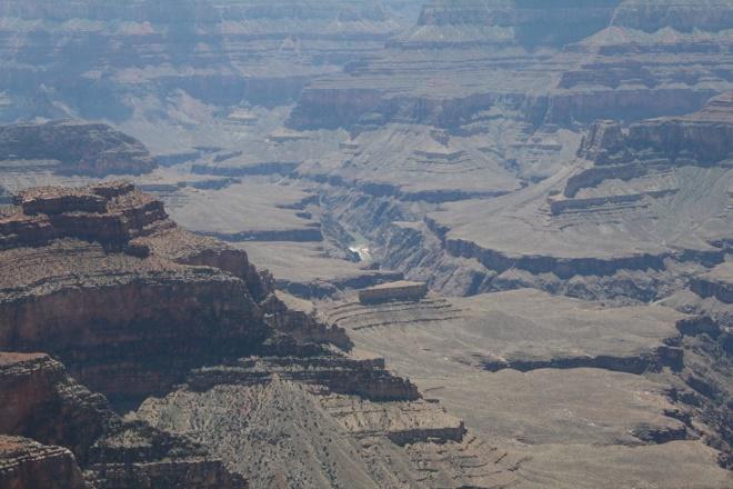
Saturday June 18 Point Sublime and Timp Point: The Point Sublime overlook is considered one of the best on the GC NR, with 270 degree views of the Grand Canyon and Colorado River. The trail is 18 miles through forest with an additional view point along the way. From point Sublime, we head to Timp Point, a west facing view of the Grand Canyon.
Point Sublime
Sunday June 19 Jumpup Point: This trail takes us out of the forest into high desert terrain with pinyon pine, juniper and sagebrush. There are a number of good view points in the area. This trail will be mostly easy with some rocky sections near Jumpup point.
Monday June 20 Buck Farm Point; This trail winds east of De Motto around the Saddle Mountain Wilderness area. We end up at Buck Farm point, an overview of the Colorado River gorge southeast of the Grand Canyon. Rumor has it this area is the best 4x4 trails on the north rim. Let’s find out!
Tuesday June 21 Relocate and restock: We will break camp at De Motto early, then travel to Kanab Utah for supplies. For the next 4 days and 3 nights we will be camping along the trail. Each vehicle must be able to pack supplies for 4 days including food, water, and shelter for each person. Each vehicle should plan gas for 300 to 350 miles. This area has mostly easy trails with soft sand and moderate rocky sections. From Kanab we will head into the GC Parashant NM and setup camp in the forest just south of Mt Trumbull.
Wednesday June 22 Whitmore Canyon overlook, Toroweap/Lava falls: These are two spectacular view points on the north rim of the GC. In the morning we will take trail 1028/1023 through the Mt. Logan wilderness area, past the Bar 10 ranch and air strip down to Whitmore canyon overlook. A beautiful canyon view 1000 foot above the Colorado River. The trail is steep and rocky in places but overall easy.
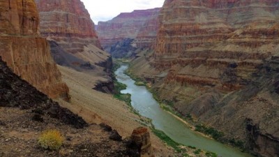 Whitmore Canyon Overlook upstream
 Whitmore Canyon Overlook downstream
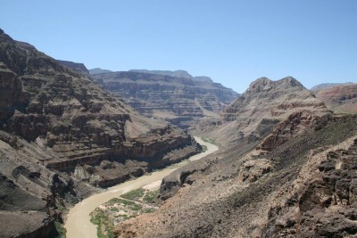
In the afternoon we will head to Toroweap view point. This is a narrow section of the GC with a 3000 foot vertical drop to the Colorado River. The trail to Toroweap is easy until the last mile that is rocky with some soft sandy spots.
Thursday June 23 Mt Trumbull school house, Hidden Canyon: We will break camp and head west on route 5 to the Mt Trumbull schoolhouse. This is a rebuilt replica of the schoolhouse that served the residents in the area. Read more about the Mt. Trumbull schoolhouse on the BLM web site.http://www.blm.gov/az/st/en/prog/cultural/schoolhouse.html From the schoolhouse we continue east on 1018 and 1003 through Hidden Canyon. The trail is mostly easy with some soft sandy sections. Camp for the night near Grand Wash cliffs.
Friday June 24 Grand Wash cliffs, Mesquite: we will break camp and head south along the Grand Wash cliffs wilderness area. Read more about the Grand Wash cliffs at the BLM web site. http://www.blm.gov/az/st/en/prog/blm_special_areas/wildareas/grandwash.html. At the south end of the Grand Wash cliffs, we will head west through Lime Kiln Canyon into Mesquite. We will stay the night in Mesquite or Las Vegas or Primm.
Saturday June 25 Head home
Special Equipment Required: High ground clearance, full size trucks and SUV’s are not recommended.
Reminder to Bring: Detailed camping checklist available upon request.