Dirt Devils Digest
June 2015
The Dirt Devils Digest
June 2015
A monthly publication of the Dirt Devils
Table of Contents
Presidents Message:
Table of Contents
1
HDR was a great time for everyone but Bill Smith (I think
Top 10 reasons to be a Dirt Devils trail leader:
2
he had some fun) Bill had a trip to the ER and 2 broke
CORVA
2
ribs. Heal quickly my friend.
Run reports
2
John Bull is next up. This is a popular but most difficult
HDR CAL4WD
2
rated SB forest trail.
Grand Canyon North Rim
2
The July AAT camping trip will be a road/trail building
The Rubicon
5
weekend. We will be working on the MC & UTV by pass
Run Calendar
6
trail around the waterfall section.
Adopt a Trail meeting place
6
I encourage all members to get involved in land use
June
6
issues. Your voice makes a difference please get involved.
July
6
August
6
The Grand Canyon north rim run was an awesome
September
7
adventure fun easy trails and beautiful views. The
October
7
complete run write up is in this newsletter and on our web
November
7
site.
December
7
New Member
7
Guests
7
Club info
7
Club membership
8
First aid kit tracking
8
Run report template:
8
DD Trail Ratings
9
Adopt a Trail
9
Adopt a trail
9
Cowbells
10
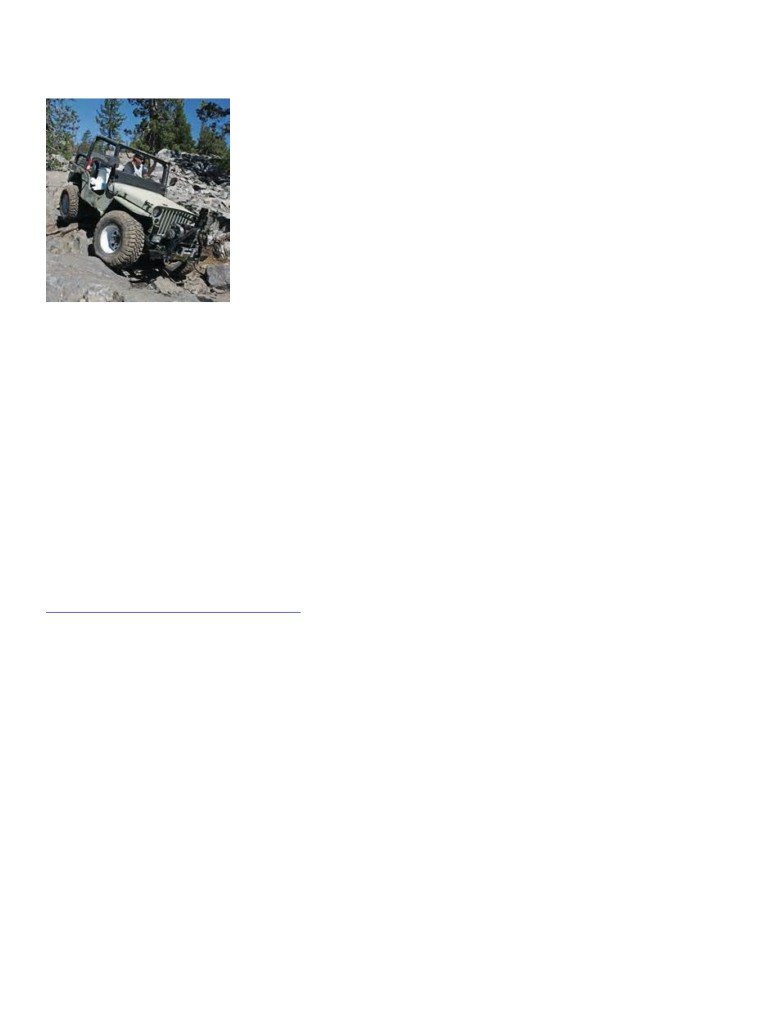
Enjoying the views.
Ray Kleinhuizen
DD newsletter jun15.doc
pg 1 of 10
printed: 6/20/2015
Dirt Devils Digest
June 2015
Our own Jesse and Keith were the organizers. They are
not available next year. If you are so inclined CAL4W is
Top 10 reasons to be a
looking for a few good citizens to plan this great event.
Dirt Devils trail leader:
High Desert Roundup is a CAL4Wheel fund raising event
10 - You pick the trail (hopefully someone will want to
raising money to keep to keep great outdoors open for
run it with you)
recreational use. As well as a good place to go wheelin’.
9 - You pick the run start time and meet spot
The Dirt Devils led the Devils loop run.
8 - You write the run announcement
7 - You pick the CB channel (duh 4)
Grand Canyon North Rim
6 - You conduct the drivers meeting (best if done before
May 30th - June 6th 2015
you start the trail)
The Team
5 - You carry the Dirt Devils club first aid kit (hopefully
1.
Ray and Karen K the run leader and planner,
you know how to use it)
drove their brown LJ.
4 - You pick the bathroom stops (more stops keep you
2.
Ron W and Chuck C in Ron’s brown LJ
out trouble)
3.
Roger M & Birdie in Roger’s YJ dragging his
3 - You are the spotter when someone needs help (you’ll
Adventurer trailer.
get a lot of exercise)
4.
Pete J driving his brown LJ and dragging his
2 - You will get unwavering support from all drivers even
Adventurer trailer.
when you are hopelessly lost and confused.
5.
Terry P in his white Grand Cherokee
1 - You get to ride in front of everyone out of the dust
6.
Chris S in his green Cherokee
(this the only good reason to be a trail lead)
7.
Danny and Linda W drove their fancy JK.
Introduction
CORVA
The north side of the Grand Canyon is known as the
Arizona Strip. It includes the Kaibab Forest to the east,
Land use matters that CORVA is keeping an eye on, read
the Grand Canyon National Park and Lake Mead
all about in CORVA’s magazine “Off Roaders in Action”
Recreational Area to the west. The Arizona strip is a
1.
Obama proposed new rule extends the reach of
rugged strip of land with elevations ranging from 4000’ to
the EPA to regulate wetlands, rivers, streams and
9,000 feet. There are few people, a few cattle ranches, one
creeks
Dude Ranch, pine trees at the higher elevations and sage
2.
Desert protection and recreation act S1441
brush at the lower elevations.
(Feinstein), you need to worry about this bill,
There is no road that follows the north rim, the terrain is a
even our Deep Creek trail could get closed off.
series of canyons and valleys that are perpendicular to the
3.
Mojave trails national monument
Colorado River. To get to the various viewpoints (the
4.
Snow national monument
views did not disappoint) it is necessary to drive 15+
5.
Five BLM study areas near Fort Irwin, portions
miles through a canyon or along a plateau to the
of Death Valley National Park, San Bernardino
viewpoint, and then back out the way you came..
National Forest, Cady and Soda Mountains
6.
Vinagre wash special management area
The Arizona Strip was very green due to recent rains this
7.
National Park System looking at adding 74,000
past month, July, and August is the wet season,
acres of land to the national park system.
commonly referred to as “The Monsoon Season”. We saw
8.
Clear Creek National Recreation Area
no running rivers, streams or lakes, some ponds in the
9.
Central Coast Heritage Protection Act
meadows. If we were in the High Sierras we would have
10. Forest Service plan revisions for the Inyo,
been crossing streams and camped alongside lakes. (after
sequoia and sierra national forest
a normal wet winter season). We saw a lot of deer that
11. BLM land use plans “WEMO” west Mojave plan
were so comfortable they wandered through camp every
12. State of California Carnegie SVRA General Plan
morning.
13. State of California Ocotillo Wells SVRA
The Grand Canyon Parashant National Monument is
General Plan
considered one of the most remote areas in the lower 48
states. Elevations range from 2500 to 6000 ft. I consider it
Run reports
mostly high desert with a few areas high enough altitude
for pine trees. There are no paved roads. (actually there
are no paved roads within 40 mile of the monument)
HDR CAL4WD
There is no water, gas, cell service or services of any
May 25 2015
kind. If you like getting away from it all this is the place
for you. Gas was on our minds the whole time we were in
DD newsletter jun15.doc
pg 2 of 10
printed: 6/20/2015
Dirt Devils Digest
June 2015
Parashant. We all made it with some margin’ Ron and
We then headed out for Whitmore overlook, one of the
Pete still had unused cans when we drove into Kanab.
most popular views on the edge of Grand Canyon. The
road starts out graded and gradually turns into a trail, at a
The Kaibab National Forest is right outside of the GC
Y in the trail we took the right fork instead of the left
National Park on the north rim. We were at much higher
fork, which led us down a series of steep switchbacks into
elevations. The DeMotte campground is at 8300 ft. All
Parashant canyon and across a plateau toward a Copper
the trails here are in the pine tree forest.
Mine. Upon realizing we had made a wrong turn, we
The weather was good, the first 2 days at the lower
made a U turn and went back up the narrow canyon and
elevations it was hot maybe in the 90’s during the day and
the switchbacks and camped at the top in a clearing. We
at night the low was maybe 43. The last 4 days at the
enjoyed out first night on the trail. Lesson learned: when
higher elevations the highs were about 70 and at night in
selecting trails on Google Earth they may not exist on
the 30’s.
your GPS’s maps.
No cowbells were earned, generally the trails and dirt
roads are easy.
Saturday, May 30
Six rigs met at the T/A center in Barstow and headed to St
George, Utah. As we were pulling into Mesquite, Ray’s
A/C stopped working. After checking fuses and other
possible failures we continued on to St George. The
compressor was bad and no one in St George had the
parts. We decided to do the run without A/C we don’t use
it much on the trail. Ron and Chuck drove straight to St
George towing Ron’s expedition Jeep.
On Sunday May 31,
After breakfast we all gassed up, made sure we had ice
Whitmore canyon overlook
and any other supplies needed for the next 3 days. Filled
Monday June 1
the gas tank and all extra cans/containers. On the way
We broke camp and hit the trail by 8:30am. We back
over to the gas station Ron’s new bumper with cargo rack
tracked about a half mile and took the left fork to
over the tire was swaying and banging the rack against the
Whitmore canyon overlook. This trail stays above
Jeep’s top. A ratchet strap and some rope over the roof
Parashant canyon dropping into Whitmore canyon just
tied to the front grill held the rack in place most of the
before the Bar 10 ranch. We passed the “Bar 10 Ranch”
time. We headed south out of St George Utah to County
Route 5 (CR5) a dirt road and aired down. The first few
past the Whitmore International Air Port and Heli Pad.
miles we climbed fast. We stopped once to look back to a
The Bar 10 ranch is a modern day dude ranch. We
great view of St George.
watched a helicopter transport people from the ranch
down to the river for some rafting. I’m sure they fly
downstream later in the day to pick everyone up.
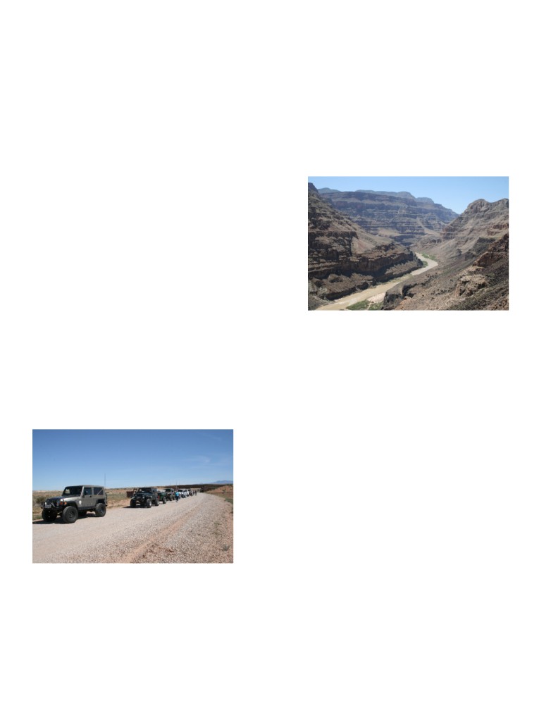
As you approach Whitmore overlook, the road does get
rougher. We descend about 1K of elevation the last 1.5
mile to the overlook. We enjoyed a great view of the
Colorado River. You can see the Colorado River 1,000
feet below. You’re so close you can hear the rapids
below. At the Whitmore overlook you are actually down
in the Grand Canyon looking up at the canyons sides and
down at the Colorado River, hard to put it in words.
We backtracked to Trumbull School House where we ate
lunch. I might add it is our favorite lunch spot. After
lunch we headed east up into the Saw Mill Mountains and
Next stop was the Mount Trumbull school house,
Mount Trumbull, the tallest peak in the area. (yes, at one
time there was a saw mill that provided lumber for St
about 60 miles south of St George. The Trumbull Valley
George). We found a spot in the forest where we were
was homesteaded by some very hearty souls. We ate
able to leave Roger and Pete’s trailers and we headed
lunch and wandered through the school house taking in
down the mountain to Tuweep.
its’ history.
DD newsletter jun15.doc
pg 3 of 10
printed: 6/20/2015
Dirt Devils Digest
June 2015
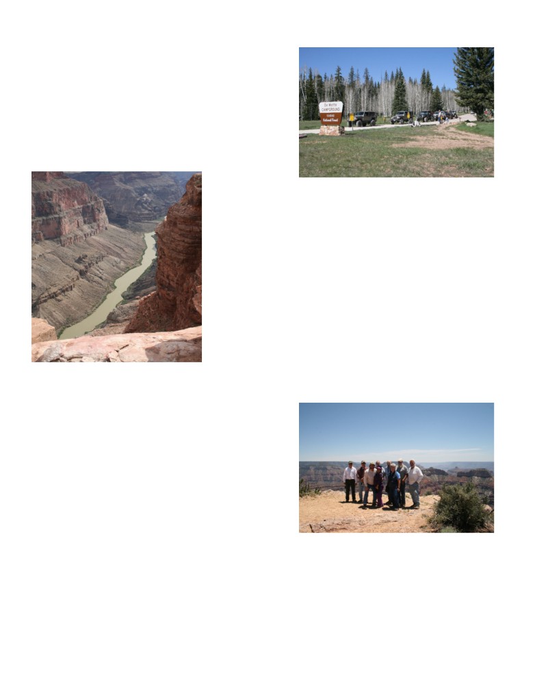
Tuweap is in the GC National Park. The trail in is easy
until the last mile when the trail becomes moderate:
Rocky and rutted but not too difficult. This is the spot on
the Grand Canyon you can see the Colorado River 3,000
feet below. (I laid on my belly to enjoy the view.). The
wind at the rim made looking over the edge a little
spooky. This is an awesome view. Too bad they no
longer allow camping right at the rim. We took a quick
look at the Toroweap campground some sites are right
against the rocks blocked from the wind, but hammering
stakes is a pain. There are no camp fires or charcoal grills
allowed and no water.
Heading to camp
Wednesday June 3
We headed to the Point Sublime trail head inside the GC
National Park. We saw several small groups of deer
grazing in the meadows as we approached the GC
National Park entrance. The trail to Point Sublime goes
through a thick Bristle Cone pint forest with a few grassy
meadows along the way. There are several hills to climb
and the occasional mud puddle. We came across a wide
spot on the trail where a large group was camping, Ray
tried to get back country permit to camp inside the
national park at Point Sublime but was told they were no
longer available. A ranger we had been following told
Ray he was given wrong information and he should have
been given a backcountry permit. Good to know for future
runs. Camping on the rim has to be a future goal.
Point Sublime may be the best views of the trip including
a 320 degree view of the Grand Canyon. The view was so
Toroweap overlook
wide, the only way to get the whole view was to put my
Tuesday June 2
camera into video mode and scan all 320 degrees. There
On day 3 went to the city of Kanab, Utah, the gateway to
is a small picnic area were we had lunch with nice views.
southern Utah and Zion. We stocked up with provisions,
ate lunch, and took highway 89A south for our camp site
at DeMotte, but along the way we had to stop at Jacobs
Lake Lodge for their World Famous Cookies. Their
reputations did not disappoint. Tim the DeMotte camp
site host and Ray’s best friend escorted us to our camp
sites where we set up base camp for the next 3 nights.
DeMotte has all the modern conveniences’ including pit
toilets, fresh water, fire rings and picnic tables. After
camp was setup at DeMotte a few of the dirty campers
headed to the National Park campground for a hot shower.
There is also a gas station, general store and lodge with
restaurant at DeMotte.
Point Sublime overlook
After lunch we headed to the Fire Point overlook using
the map and GPS to find our way. Neither Garmin nor
Google earth showed a trail between Point Sublime and
Fire Point. The Kaibab Nation Forest map did show a
trail. After a little exploring we found our way through to
Fire Point. Fire Point is a west view into the Grand
Canyon. The canyon walls are very green in this section
of the canyon.
DD newsletter jun15.doc
pg 4 of 10
printed: 6/20/2015
Dirt Devils Digest
June 2015
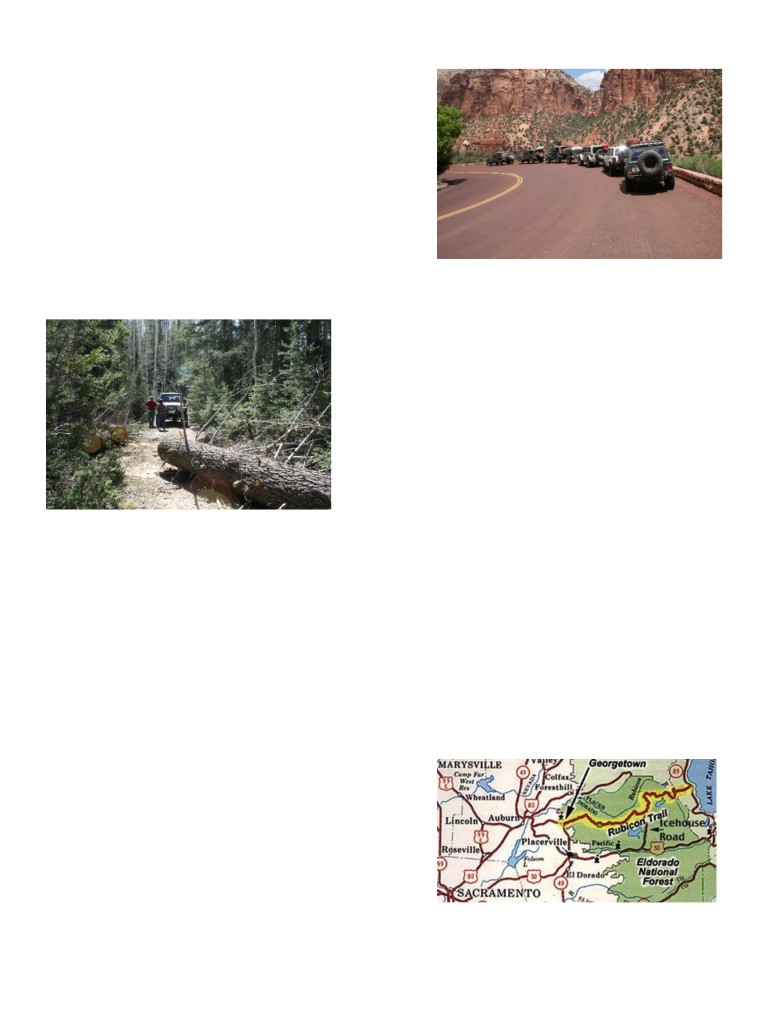
Thursday June 4
Everyone woke up early and we headed off for Crazy Jug
viewpoint, Monument Point and The Bill Hall trail head.
The trail winds through a thick forest valley, occasional
meadows and patches of snow. The snow did provide an
opportunity for a brief snow ball fight.
After about an hour we heard Ray over the CB say oh, oh
we have a problem. A large tree had fallen across the
narrow trail and there was no way around it. We did not
turn around, the team went into adopt a trail mode. We
grabbed our axes, saws and other implements of
destruction and cleared the area. Once the area was clear
we attached a snatch block to a nearby tree and ran the
The south section of Zion has petrified sand dunes, large
winch cable through it and wrapped it around the fallen
rock formations that look like developing arches, and a
tree. 15 minutes later the tree was off to the side and we
narrow almost one way tunnel. We stopped for lunch on
were ready to proceed.
Bridge road and watch a storm with lighting and thunder
move right over us. (time to hit the road)
Danny and Linda skipped lunch said goodbye to everyone
and headed for Las Vegas for the night. We got to the 15
fwy soon after lunch. Ron and Chuck had booked a room
at the Fairfield in St George. The rest of the group
decided to make the long drive home without stopping for
the night. Karen and I got home about 10:15 California
time.
Overall an awesome trip with a great group of people.
The Rubicon
According to Wikipedia
From Crazy Jug to Bill Hall. The trail follows the rim.
This would be a great area to camp and wake up in the
Rubicon Trail is a 22-mile-long route, part road and part
morning and have a cup of coffee while taking in the
trail, located in the Sierra Nevada of the western United
beautiful view. The trail dead ends at the Bill Hall Trail
States, due west of Lake Tahoe and about 80 miles east of
Head. We parked and walked along the first part of the
Sacramento.
trail that takes you to the bottom and the Colorado River.
When we returned to our rigs, Roger had a flat tire, there
The maintained portion of the route is called the
was a slice in the side wall of his new Good Year MTRs
McKinney-Rubicon Springs Road; it begins in
with Kevlar reinforced side walls. 6 plugs later the tire
Georgetown, California, a hamlet in California's Gold
was repaired, after airing up we were off. While at
Country.
Monument Point I noticed when standing close to the
The road continues from its intersection with State Route
edge you could not feel the wind that was blowing hard.
193 towards Wentworth Springs, where the trailhead for
But when standing a hundred feet away you could feel the
the unmaintained portion of the route exists adjacent to
wind. This is due to the strong updraft effect of the wind
Loon Lake.
coming out of the canyon.
The trail portion of the route is about 12 miles long and
Friday June 5
passes in part through the El Dorado National Forest."
Chris had been telling us there was a forecast of rains on
this day. He was correct the rain, hail and thunder hit
about 7:30am while some of us were eating breakfast. The
smart ones went to the Lodge for breakfast. After that it
did not take long to get the wet gear loaded and we hit the
highway back to Jacob Lake (cookie re-stock) and Kanab
for gas. From Kanab there are 2 roads back to St George.
We took the road through Zion National Park. We were
able to enjoy more great views, rain, hail and lightening.
The thunder sounded like artillery.
DD newsletter jun15.doc
pg 5 of 10
printed: 6/20/2015
Dirt Devils Digest
June 2015
The history of the Rubicon Trail taken from
Run Calendar
that "in 1887, the El Dorado County Board of Supervisors
Adopt a Trail meeting place
declared the trail (or highway) from Wentworth Springs
through Hunsucker Springs (Rubicon Springs) a public
8:30am at Rocky’s Roadhouse
highway.
32150 Hilltop Blvd Running Springs, CA 92382
next to the 76 gas station
To ensure that the trail remained open for public use, in
1991, the Board of Supervisors reconfirmed the Rubicon
Trail’s status as an unmaintained County right-of-way.
June
From the 1880s into 1940s, the Rubicon Trail was used to
19th - 21st Forest Fest Big Bear Father’s Day weekend
move cattle, sheep, and turkeys from the western slopes
register is open and generally fills up fast, if you are
of the Sierras to the Meeks Bay area for summer grazing.
interested register online at
It was also used to provide access to the resorts located at
Wentworth Springs, Rubicon Springs, and the west shores
27th John Bull (D) - Josh
of Lake Tahoe.
a Black Diamond trail
Later residents of California used the area for hunting and
July
fishing, just as the Maidu had hundreds of years before.
Shortly after the Eldorado National Forest was
7th club meeting
established, the U.S. Forest Service prepared a map
10th - 13th Bishop Ca. trails - Ray
showing areas where various game and fish species could
Easy run on Saturday up the White Mountains then will
be found.
do a harder one after.
In the 1920s, cars (Dodges and Stars) could travel the
24th - 26th Adopta Trail overnight camp
route from Georgetown to Rubicon Springs they used
tent peg campground Big Bear
“ropes and planks” to cross some of the rougher spots.
run Leader Roger .
Car skeletons found along the trail in the early days were
said to be proof of the trail’s difficulty.
23rd - 26th Jeepers Jamboree
El Dorado County officials eventually decided to develop
31st - 2nd Jeep Jamboree
the Rubicon Trail as an improved route from Georgetown
represent the Dirt Devils on the 31st
to Lake Tahoe.
They rebuilt the wooden bridge across the Rubicon River
August
in 1939.
In 1947, the County ordered the construction of a steel
1st Swap meet and pot luck dinner
bridge over the River to replace the log bridge. The steel
1pm dinner at 4pm
bridge was constructed in Placerville and transported to
details to follow
the site.
At Ron & Emi Webber’s house in beautiful Modjeska
Canyon (near Irvine Lake).
To ensure that the various pieces of the bridge would not
shift on the trip to the bridge site, they were welded to the
Drive a pick up truck with your spare parts, camp gear or
frame of the truck.
just yourself; bumpers, lights, wheels & tires, gas tanks,
roof top, alternator, drive shafts, axles, battery box,
The bridge components were moved into the area via
suspension parts, springs, straps, etc.
Lake Tahoe and Rubicon Springs.
In 1952, several residents of Georgetown met to discuss
the possibility of hosting an organized Jeep tour from
4st club meeting
Georgetown to Lake Tahoe via the Rubicon Trail.
On August 29, 1953, 55 Jeeps with 155 participants left
Georgetown on a two-day trip that is now known as
"Jeepers Jamboree 1."
Every year during the last weekend of July, 4-wheelers
follow the tradition of these “pioneers.” "
DD newsletter jun15.doc
pg 6 of 10
printed: 6/20/2015
Dirt Devils Digest
June 2015
6th
- 9th Sierra Trek near Truckee CAL4WD event.
Guests
Mark Horist ’93 YJ he received a Dirt Devil business
card.
Curt Clark ’04 Rubicon
Rick Schaffer ’92 YJ
David Hawkinson and Susan 2000 red TJ w/ 33’s, lockers
and a 4” lift
Ron and Debbie Robinson ’15 white Rubicon w/ 35’s and
a 2 ½” lift
Bil Gallio green ’97 TJ w/ 33’s
Kraig Adams ’08 F350 10” lift and 38’s
Debbie and Troy Craddock 2012 Rubicon
John Strege ’97 TJ wrangler a former member.
15th 4x4 Big Bear Clinic (E/M) - Mike
Dave Mauer
22nd Adopt A Trail - Roy
Al Ramsden
Mike Ramsden
September
Ramon Del Toro
1st club meeting
Marcos Del Toro
4th -
7th High Sierra Poker Run CAL4WD event.
near Shaver Lake
Eric Yoshioka
11th - 13th Sherman Pass (M) - Danny W.
Club info
19th Adopt A Trail - Josh
Last Saturday of September Adopt a Trail BBQ
Meeting Place
October
First Tuesday of each month,
6:30pm for Dinner & 7:30pm for the meeting at
6th club meeting
just east of Imperial Hwy and north of the 91 Fwy.
3th & 4th Off Road Expo Pomona
Marie Callenders. 5711 East La Palma Ave., Anaheim,
CA 92807, 714-779-0600
6th Monthly club meeting
16- 17 Operation Desert Fun
Club officers
17th Miller Jeep Trail (M) - Pete
President: Ray Kleinhuizen
kkfusedglass@roadrunner.com
24th Adopt A Trail - Lead TBD
Immediate past president:
Jesse May: jemay.xj@gmail.com
November
Vice President: Mike Wallace proudpop80@gmail.com
3rd Monthly club meeting / run planning 2016
Secretary: Cheryl May: jemay.xj@gmail.com
6th - Black Canyon (E) - Ray
Treasurer: Emi Webber: emiwebber@hotmail.com
12th - 14th Panamint Valley Days (PVD), Cal 4 Wheel
Web Master: Chris Slaughter:
event
webmaster@dirtdevils.org
Adopt a trail chairmans:
December
Roy Chance: rchance@aol.com
1st Monthly club meeting
Roger Mauer: rogermauer@gmail.com
5th Cleghorn (M) - Joel
Newsletter: Ron Webber: ronjp@outlook.com
Hospitality: Emi Webber: emiwebber@hotmail.com
New Member
Safety Committee: Bill Smith:
Rod and Carol Abbott
Run Coordinator: Rick Walter rick03tj@gmail.com
DD newsletter jun15.doc
pg 7 of 10
printed: 6/20/2015
Dirt Devils Digest
June 2015
Emergency response team coordinator: Rick Walter
Ray Kleinhuizen
rick03tj@gmail.com
Mike Wallace
the emergency response team makes themselves
Josh Bleijenberg
available to help with our adopt a trail Dish Pan.
Ron Webber November 2014
CAL4 wheel reps: Jesse May and Keith Graham
Ray Kleinhuizen July 2014
FA #2 (Orange canvas bag)
Club membership
Josh Bleijenberg
Membership dues:
Pete Johnson
Dirt Devil annual club dues
$36.00
Josh Bleijenberg corral cyn then handing off to Pete
Spouse
$12.00
Ray Kleinhuizen
CAL4WD annual dues
$45.00
Danny Ward
CAL4WD permanent member
$675.00
Josh Bleijenberg April 2014
CAL4WD permanent member 12 installments of ...$56.25
Roger Mauer Feb 2014
CORVA
$30.00
FA #3 (Orange canvas bag)
Danny Ward
Ron Webber March 2015 Calico
Rick Walters July 2014
Accessories
Pete Johnson April 2014
Available at the regular meetings, see Emi Webber.
Ron Webber March 2014 Calico
Dirt Devil Stickers: $15.00.
Run report template:
Short sleeve shirts: $15.00
Long sleeve shirts: $18.00
Run name:
Sweatshirts: $30.00
Run leader:
Hats: $20.00
Date:
DD logo magnets available in various sizes for
Number of rigs:
$4.50 to $13.50 each.
Participants:
Members:
Awards
Guest:
The story:
Weather:
Cow bells earned:
Run announcement template
Research and/or Pre-run the trail route.
Create and Post a Run Announcement
When emailing the run announcement: Please, use the
words “Run Announcement” in the Subject line of the
message, forward to the webmaster and newsletter editor.
Date/Time and Place for the Run
Description of Run
Difficulty Rating
Run Type: Base Camp, Day Run
CAL 4 Wheel Drive, new member award
Directions to Meeting Place.
EXACT Departure Time from Meeting Place
Newsletter advertising
Required Equipment. Open dif ? Lockers?
$25 for ¼ page ad, for 3 issues
Is RSVP Required?
$50 for a ½ page ad, for 3 issues
CB Channel channel 4, if to much traffic then switch to 5
$100 for a full page ad, for 3 issues.
and so on.
A full page ad also gets a Web Link.
HAMM channel 146.440
First aid kit tracking
Camping Location/ Directions/ Details/ Facilities/ Fees.
Access for motor homes?
FA #1 (red, blue backpack)
DD newsletter jun15.doc
pg 8 of 10
printed: 6/20/2015
Dirt Devils Digest
June 2015
Contact Information (Run Leader
•
(M) Moderate trails could include these
Phone Number & email address)
conditions::
• Steep rutted and rocky hill climbs that require careful
Day of the Run:
tire placement.
Hold brief driver’s gathering before start of run. Include
• Two to three foot ledges to climb and/or steep down
special instructions.
hill drop offs.
Assign vehicle order if there are vehicles with open diffs.
• Rocky sections that can cause body or rim damage.
Have vehicle with locked diff in front & behind. (If
• Water crossings might have rocks and could be
possible disperse vehicles with HAM radios near the
deeper then 12 inches.
front, middle and rear of the line.
• Brush or cactus may touch vehicle.
Encourage drivers to learn the name of the person in front
• These trails will require low range gears, high ground
and behind his/her vehicle.
clearance and 4WD.
Assign Tail Gunner Vehicle
• Skid plates and body protection are recommended.
After returning home forward to the newsletter editor a
• Minimum 33 inch or bigger tires.
Run Report and a few photos. subject line write
• Recommend at least one axle locker.
“Run Report”
(D) Difficult trails could include these conditions:
• Rocks as big as your tire to as big as your vehicle.
DD Trail Ratings
• Hill climbs are steep and may require extended wheel
Trail ratings are subjective and weather conditions over
travel.
the years can change a trail. An easy trail can become
• These trails can have long sections of large rocks that
more difficult after or during rain. The trail leader needs
require careful tire placement. .
to be the final judge of trail conditions the day of the run.
• Three + foot ledges to climb and steep drop offs.
If any part of a trail is difficult the trail is rated difficult. If
• Body damage is possible and brush may scratch
difficult sections have bypasses the trail may be suitable
vehicle.
for less capable rigs or less experienced drivers.
• These trails will require vehicle modifications such as
E - Easy (Black Canyon, Mohave Trail)
suspension lifts, body protection and skid plates.
M - Moderate (Devils Loop, Miller Jeep Trail)
• Minimum 35 inch or bigger tires.
D - Difficult (John Bull, Calico)
• Recommend front and rear axle lockers.
(E) Easy trails could include these conditions:
• Any dirt, sand or gravel road.
Adopt a Trail
• Gentle to mildly steeper hill climbs, mild rocky
The Dirt Devils Adopt A Trail is: Dishpan Springs Trail
sections and/or soft sandy sections.
(3N34)
• Four wheel drive may not be necessary all the time.
Dishpan Springs Trail can be found in the
• Pot holes or ruts that require high ground clearance.
San Bernardino National Forest near Lake Arrowhead.
• Water crossings are up to 15 inches deep.
The Dishpan Springs Trail is one of the toughest and most
• Suitable for full size vehicles.
popular trails in the SBNF.
• Low gears may be required on hill climbs.
• Recommend 4 wheel drive vehicle
The West entrance:
2N26Y is N34° 16.198 W117° 08.258.
• Suitable for most tire sizes
The T6 Bridge:
N34° 16.106 W117° 07.745.
The East entrance:
3N16 is N34° 15.663 W117° 05.116.
Meeting place
8:30am at Rock Road House
32150 Hilltop Blvd Running Springs, CA 92382 next to
the 76 gas station
Adopt a trail Current hours - 192
DD newsletter jun15.doc
pg 9 of 10
printed: 6/20/2015
Dirt Devils Digest
June 2015
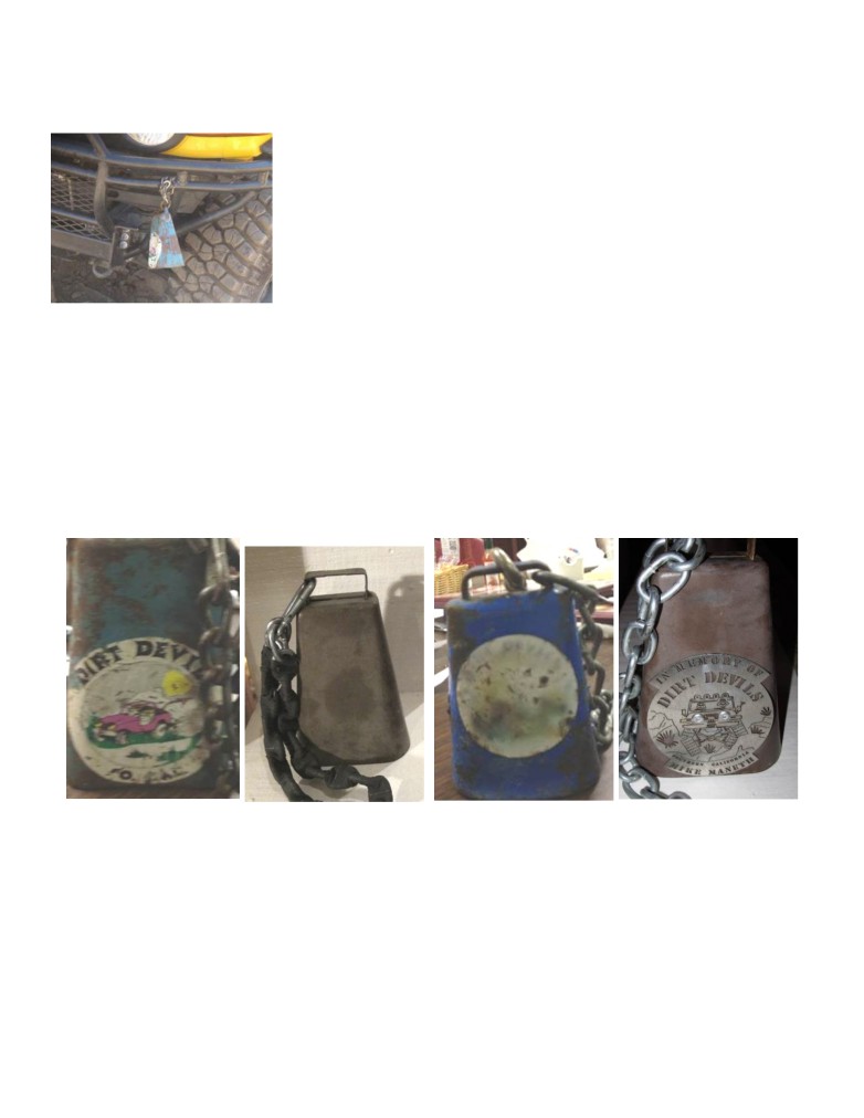
Cowbells
1.
Old logo green bell
Josh Bleijenberg Corral Canyon 4/10/15
Josh Bleijenberg Dusy Ersham Sept 2014
2.
Brown bell
Bill Smith HDR May25 2015
Tim Debolt Rattlesnake Feb 2015
Rick Walter adopt a trail 6/27/2014
Josh Bleijenberg Corral Canyon 5/4/2014
3.
Little Blue bell
Bill Smith HDR May25 2015 winched Bronco on to
trailer
The cow bell rules are: If you get stuck and are unable to
Gilbert at Corral Canyon 4/10/15
move under your own power and need the help of a winch
Chris Slaughter Grizzly
or you get strapped from one of your fellow jeepers then
Rick Walter
you have earned the privilege of hanging a cow bell from
Mike Wallace
your front bumper. You must leave the cow bell on the
4.
Mike Maneth memorial bell
front of your rig until another Dirt Devil gets stuck then,
Mike Wallace Corral Canyon 4/10/15
you can proudly hand it over. This starts at the beginning
James Eddinger Claw Hammer 1/10/15.
and the end of the trail, not on the highway.
Castulo Olivas
Old Logo Green
Brown
Little Blue
Mike Maneth Bell
DD newsletter jun15.doc
pg 10 of 10
printed: 6/20/2015